|
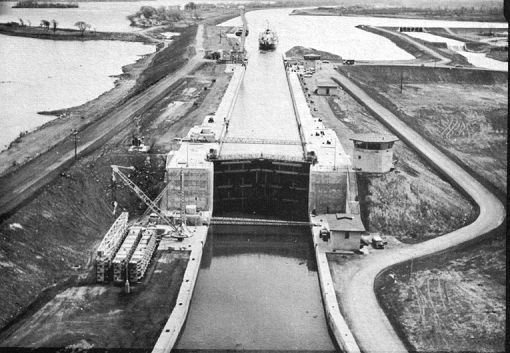
The St. Lawrence Seaway The St. Lawrence Seaway in its broadest sense is a deep waterway extending some 2300 miles from the Atlantic Ocean to the head of the Great Lakes at the heart of North America; the St. Lawrence Seaway extends from Montreal Harbor to Lake Erie and includes the Welland Canal. Description of Navigation Facilities St. Lambert Lock, at the southern end of the Victoria Bridge. (At Victoria Bridge are lift spans and a system of of rail and road traffic diversion). The St. Lambert Lock lifts the ship some 15 feet from the level of Montreal harbor to the level of Laprairie Basin through which the channel sweeps in a great arc 8 ½ miles long between its protecting embankments to the second lock. The Cote Ste Catherine Lock, like the other six new Seaway locks and the seven lift locks on the Welland Canal, has been built to the following standard dimensions:
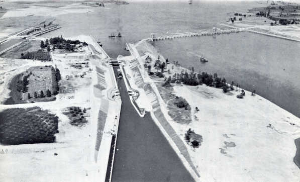
This lock, which requires 24 million gallons of water to fill, can be filled or emptied in less than 10 minutes. It lifts ships from the level of Laprairie Basin through 30 feet to the level of Lake St. Louis. The function of this lock is to bypass the Lachine Rapids. Beyond it, the channel runs 7 ½ miles before reaching Lake St. Louis. Lake St. Louis and the Beauharnois Locks The minimum width of the of St. Lawrence Seaway channels is 200 feet when provided with two embankments, 300 feet when there is only one embankment, and 450 in the open reaches. The depth in canals and channels is 27 feet. The Lower Beauharnois Lock by-passing the Beauharnois Power House lifts the ship 41 feet so that it may pass through a short canal to the Upper Beauharnois Lock, where it is again lifted 41 feet so as to reach the level of Lake St. Francis; after some 13 miles in the Beauharnois Canal the ship enters Lake St. Francis. It sails westward for some 30 miles by dredged channels to the head of the lake. All locks and channels to this point have been built by Canada’s St. Lawrence Seaway Authority. The United States Locks: The ship canal leaves Lake St. Francis at the southwest corner and before long crosses the International Boundary just opposite St. Regis, Quebec. From here to the first lock on the United States side is only 5 miles. Entering the Bertrand H. Snell Lock, the ship is lifted 45 feet into the Wiley Dondero Canal. (10 miles long) and is then lifted another 38 feet by the Dwight D. Eisenhower Lock into Lake St. Lawrence, the power pool on which HEPCO and PASNY draw for the water used in the turbines at Barnhart Island-Cornwall Powerhouse Dam, just a mile to the north. The ship canal through Lake St. Lawrence passes where rapids once tossed the water into an angry foam. At the western end of Lake St. Lawrence, the Seaway Authority of Canada has built a lock to allow ships to bypass the Iroquois Control Dam. The lift here is only about one foot. Once in the waters of the St. Lawrence west of Iroquois, the ship channel meanders through the Thousand Islands past Prescott, on to Kingston or Cape Vincent on Lake Ontario. |